Thursday, July 28, 2022

The Saddlebacks and a Big AT Milestone: July 19-22

Top of the Saddlebacks

    This stretch of Trail covered ~30 miles, and it was quite a haul for us.  This 30 miles involved climbing and descending five 4,000 foot peaks in the Saddleback and Crocker Mountains.  But the hard work required to reach these summits was rewarded with some of the most spectacular views we've had since the White Mountains in New Hampshire.  
     The Saddlebacks were incredibly gorgeous, if a bit windy in the 4 miles of Trail above treeline.  We had 360-degree views of the Rangely Lakes and because there were several open summits to climb one after another, we were able to look back across the entire ridgeline we had climbed before we made the big descent off the Saddlebacks.  Views well worth the sore feet and burning hamstrings.   
   
Clouds Clearing over the Saddlebacks

Windy Lunch at the Summit 

...very windy...

Hiking above Treeline

     We had originally planned to complete this stretch of Trail in 3 days/2 nights.  But after hiking 11 miles over 3 of the Saddleback peaks on the first day of this outing, I had to concede that I had overestimated my abilities.  We only hiked 8 miles the second day, camping a bit early to give our legs a bit of time to rest. This meant we had to re-evaluate our logistics a bit, since we would now either have to spend a 3rd night out camping or find a different way for Trail Angel to pick us up.  Luckily, Trail Angel is the Queen of Logistics and Secret AT Backroads, so with our last granola bar and thunderstorms in the forecast, we hikes ~5 miles to an old logging road and got picked up just in time to get out of the rain.  We hiked the last 8 miles over the Crocker Mountains the next day, well-fed, dry and with just our slackpacks on.  This last 8 miles included a very special milestone:  the 2,000 mile mark for Northbound AT hikers.  It's hard to believe that Amicus and I have *walked* 2,000 miles on a continuous Trail (albeit in pieces) - on purpose, for fun.  Now with less than 200 miles to go, the end is closer than ever.     

2000 miles of AT hiked!

    This was a pretty difficult stretch of Trail for us, with multiple 4,000 foot peaks to tackle.  After this stretch, we happily indulged ourselves in our favorite Trail pastime - finding the best local eateries and sampling as much as we can.  Since we're in Maine, it won't be hard for anyone to guess what Team Nano (those of us without a shellfish allergy) was craving.  2,000 miles and counting, Friends of Nano.  More mountains, lakes and lobsters ahead.    
   
Rewards for Hungry Hikers in Maine.


Monday, July 25, 2022

Trail Angel Joins the Hike - June 15/16

Not a bad spot to spend a night.

Team Nano on the Trail

    For our next section of hiking, Trail Angel was able to actually hike with us.  Any Friends of Nano who have followed us before know that Trail Angel is the glue that holds the whole team together.  She picks us up, drops us off, makes sure we stay supplied with clean clothes and good food, and overall ensures our survival.  Without her this would be a completely different and entirely less pleasant experience.  I am reminded every time I come to the Trail how blessed we are to have our own personal Trail Angel - a privilege very few long distance Trail trekkers have.  But sometimes when the logistics and geography line up just right, we get to have Trail Angel with us while we hike and those times are truly special.  

    This section of Trail didn't have any particularly formidable named peaks to conquer, but it did have something that the Maine AT is also well known for - water features.  There are lots of streams, lakes and ponds on the AT in Maine, many of them very beautiful and well-loved by locals.  We will encounter more of them the further north in Maine we hike, but we got a wonderful taste of some Maine mountain lakes on this hike.    
The AT in Maine even has beaches!

    We made camp for the night by one of these ponds.  This pond is reportedly a very good place to see moose, and since seeing a moose on the Trail is one of the last creatures on my "AT Wildlife Bingo" List, I was really hoping to check that box.  Alas, although we got sung to sleep by a symphony of bullfrogs, that was the only wildlife we saw at camp.  Moose are notoriously elusive and even at this prime spot none made an appearance.  
Suppertime at Camp Nano

Not a moose...


    Overall it was a lovely stretch of Trail.  We even finished our hiking early enough on the second day to get cleaned up and explore the small Trail Towns around this part of the AT.  As always, stay tuned Friends of Nano.  More to come.    

Team Nano with 13 more miles behind us

Sunday, July 17, 2022

Nano's Long-Awaited Return

Friends of Nano - after 8 very long years I am delighted to dust off this blog and welcome you back to this Grand Adventure.  So much has happened since we were last here, and in many ways I am a very different Nano than I was in 2014, so allow me to catch you up on nearly a decades worth of life.  

PERSONAL UPDATES
Most importantly, Team Nano has a new member - Uno.  It feels strange to "introduce" Uno as my husband now that we've been married for 7 years, but this will be his debut on the Grand Adventures Blog.  Long distance backpacking wasn't a hobby of his before I got my hands on him, but now he Adventures with the best of them.  He's been on a few short trips to the AT with me since we've been married but this will be his first extended trip.  I have no doubt he will do amazing in the Wild, like he does everywhere.  He is the last missing piece this Grand Adventure needed.  

Nano and Uno, Adventuring Together since 2015


PROFESSIONAL UPDATES
When I first started this Grand Adventure, I had just graduated college.  When I last blogged, I was almost finished with medical school.  Now, I am not only finished with medical school but residency and fellowship.  11 years of medical training between two states is now complete.  Emotions too numerous to list come with this achievement - excitement, relief, extreme happiness, some fear of what's to come.  But I can think of no better way to celebrate this milestone than a nice long walk in the woods to bridge the "training" and "real world" chapters of my life. 

Nano, MD

TRAIL UPDATES
Since 2014, Team Nano has made three short trips to the AT.  It was difficult to make much progress when I could only take one week off at a time during residency and fellowship, but we did manage to hike ~60 miles of Trail between those trips.  Our most recent trip was in May 2019, when we managed to make it to what is widely known as the "Hardest Single Mile" of the AT - Mahoosuc Notch.  This mile of Trail is infamous among locals and thru-hikers alike.  While theres only ~350 feet of elevation change, the entire mile is a field of giant boulders that requires more climbing/crawling/jumping/falling than hiking to traverse.  Being naive Southerners instead of mountain-folk, we did not anticipate that even in late May, the Mahoosuc Range in Maine would still be completely full of snow and ice.  We arrived at the southern end of the Notch after hiking several miles over snow in crampons, took one look at the icy boulders, and promptly headed straight out a side trail to Trail Angel so that Team Nano could live to hike another day.  

Team Nano - very cold on the AT in 2019

Iced-in Notch in 2019


PRESENT DAY
Which brings us to today.  Now that all my medical training is finished and I am able to take some time off, naturally, the first thing I wanted to do was continue (and possibly complete) this Grand Adventure.  After packing up our fellowship life we headed straight to Maine promptly hit the Trail. 

DAYS 1-2
We spent the first two days hiking just 10 miles of Trail.  We had to start where we last left - at the previously iced-over Mahoosuc Notch.  No ice this time, just a solid mile of giant boulders. Overall between the terrain and my woefully out-of-Trail-shape legs it took us a little over 3 hours to navigate the Notch.  We made it out exhausted but with only one fall (me), but nothing serious.  Because the AT is a cruel mistress, we had a brutal climb to tackle right after, but we went slow and managed.  We slept well at camp that night and made it up and over one more climb the next day to rejoin our Trail Angel, as well as Hooter and Mrs Hooter who came all the way from the Deep South to join us for the first part of this leg of our journey - a truly special treat. 
Entering the Notch - no ice this time.

It was 3+ hours of this...

DAY 3
Hooter and Mrs Hooter joined us for our third day out for a bit of "slackpacking."  We were able to hike 10 miles over the Baldplate Mountains, and although it was a tough hike with lots of elevation change, we were rewarded with a beautiful day and some spectacular views.  Even after spending just two days carrying my big pack, it felt wonderful to be able to travel light.  We treated ourselves to some giant sandwiches from an amazing local grocery store after and went home very happy campers. 

Team Nano at the Baldplate Summit


DAY 4 
Another day of "slackpacking" and 10 more miles in the books for us on our fourth day of hiking.  We had to break out our rain gear for about an hour today, but luckily the downpour didn't last long.  The near-constant elevation changes the AT in New Hampshire and Southern Maine are famous for continue.  The terrain is rarely ever flat and therefore we're almost always on a (seemingly usually steep) incline or decline.  The Maine Trail Crews have worked hard to make this terrain traversable and we saw (and were thankful for) evidence of their efforts while we were climbing today.  Despite getting wet, all was well when we got to go back to Trail Angel, the Hooters and a home cooked meal. 

Wet on the AT

Typical Maine AT Climb

DAYS 5-6
We said farewell to our dear friends the Hooters the morning of our 5th day of hiking and set out for an overnight section.  Some more "Classic Maine" steep climbs and descents, but with some special treats.  We found "the best bench in Maine", caught a gorgeous sunrise over Bemis Mountain, met a family of grouse, and made it off the Trail on the second day before the thunderstorms rolled in.  As Hooter would say - "it's all about timing."

Nano, Uno and the Best Bench in Maine

Sunrise on Bemis

The Calm Before the Storm

Overall, we hiked nearly 50 miles this week, and in this terrain with as out of practice as I am, I'll take it.  It feels so good to have my hiking boots on again.  Stay tuned, friends of Nano, we're just getting started (again...)    


Wednesday, July 30, 2014

Feeling Presidential

The past two days of hiking have included some fast thinking and some grand sights.  We entered a very famous section of the AT known as "The Presidentials," since most of the mountains over this 20+  mile stretch of trail were named after…you guessed it…former presidents of the USA.  This is a section of the AT that hikers anticipate with both excitement and a healthy dose of fear.  Excitement because the Presidentials, like the rest of the Whites, boast stunning scenery, as well as a huge Trail milestone -  the summit of Mt. Washington, the 2nd highest peak on the AT.  The fear comes into play because this area is known for its incredibly volatile weather.  As any local hiking enthusiast will tell you, hikers have been seriously injured and even killed in these mountains due to the extreme and often unpredictable conditions, even in summer.  I think that Team Nano got a truly Presidential experience on our journey over the past two days, in more ways than one.

DAY 1
Living up to their reputation immediately, The Presidentials threw us a curveball before we even attempted the first summit.  After spending the evening relaxing with Trail Angel, we awoke on the day of our planned Presidential Outing to rain.  Lots and lots of rain.    We were promised volatile weather after all.  Nevertheless, after waiting out the rain for a bit we were able to hike about 7 miles and visit our first "Presidents":  Mounts Webster and Jackson.  Even in the cloudy haze, this part of the AT, lots of it above treeline after an initial ascent, is truly beautiful.  We spent the night at Mizpah Springs Hut looked after by another wonderful crew and went to bed warm, dry and with a belly full of homemade food. The hut hiking life is going to be dearly missed after we pass through the Whites. 

DAY 2
Day 2 of this outing had us meeting a few more "Presidents": Mounts Pierce, Eisenhower, Franklin, Monroe, and one of the crown jewels of the AT - Mount Washington.  The entirety of this hike was above treeline and we were blessed with a beautiful mountain day.  The climb up Mt Washington took us over 6000 feet above sea level, and it was easy to see why hikers are warned so adamantly about this part of the Trail.  Exposed, rocky, sparsely marked and both stark and stunning, it's not somewhere I would want to be trapped in a storm.  Luckily, the Mountain put on a truly spectacular show for us and we enjoyed 360 views all day.  After stopping for lunch at Lake of the Clouds Hut, we ended this stretch of time on the AT at the summit of Mt Washington, feeling very "Presidential" indeed.  Overall this was one of my favorite sections of the AT so far, and I can't wait to be back.  Stay tuned friends of Nano, the Grand Adventure will continue.    

Climbing Mt Washington, Lake of The Clouds Hut in the distance.


Team Nano at the Summit.


Sunday, July 27, 2014

Return to the Whites - July 23-27, 2014

Nano is back in the Whites

Hello, friends of Nano.  Though it has been a year since our last adventure, I am very happy to be venturing out onto the trail again, if only for a short time.  Now that another year of medical school is on the books, I have a little bit of time to enjoy myself before pushing on to the MD.  What better way to do that than a return to the AT?  And with our favorite trail friend Hooter with us!  I had been looking forward to getting back on the trail all year.  We are right in the middle of the White Mountains, which boasts some of the most spectacular and most demanding (spectacularly demanding?) hiking of the entire AT.  We've actually been on-trail for a few days, but I haven't had a chance to update until now.  It's going to be a long post to cover all the days we've been out.  So here we go.  Hold on tight.

DAY 1  
Not ones to dip our toes timidly into the AT, our first day back started with a long, steep, very rocky climb.  We plotted our course assuming that we would go about 1mile/hr, which even seasoned local hikers here will tell you is a decent pace given the terrain.  There was a designated campsite only a few miles into our climb, and because we got a relatively late start and camping in the Whites can be precarious if you get stuck in one of the many exposed sections, we considered staying there.  However, we had some of the most famous hiking on the entire AT ahead of us.  Motivated by the promise of a view we'd never forget, we pressed on.  After 5 very difficult uphill miles, we were not disappointed.
Our trail on Day 1 of our return

What you see in the picture above is Franconia Ridge, and it is one of the most famous pieces of the entire AT.  It is a little over two miles of trail that follows a knife-edge ridge above the treeline, with near-vertical drops on either side of the trail, which is about 2-3 feet wide.  And of course, stunning views in all directions.  It's a place thru-hikers hear about often and dream of getting to.  It was windy but a beautiful day, so we took our time crossing the Ridge, stopping to take lots of pictures and take in the sights.  We were not sorry we passed on the "official" camping sight at the south end of the Ridge, and by the time we settled in for the night after descending back into the forest at the north end, we were a bunch of happy hikers.    

DAY 2
Our second day out greeted us with more hard hiking.  Like the vast majority of the hiking in the Whites, today was a long series of steep downhill slides followed by even steeper uphill climbs, with nary an inch of anything resembling flat trail in between.  We started the day by finishing our climb down the mountain following Franconia ridge.  There was a pond at the bottom of the mountain, where we stopped for "second breakfast."  As we munched our granola bars, we heard whoops and shouts from near the water.  A group of college boys who had camped slightly north of us had just discovered the pond and decided it was a perfect time for skinny dipping.  Background information:  it was approximately 9am and 50 degrees outside.  The filtered water in our bottles had just come from the pond, and it couldn't have been any colder if it had come from the fridge.  No wonder those boys were whooping.  Fully fed and hydrated, we headed up the next mountain, where the trail really started earning its reputation for challenging all who dare set foot upon it.
 
Nano on the AT:  Billy Goat Style

What we did on our way up this climb (and indeed, quite often throughout this section of AT) more often resembled rock climbing than hiking.  But as always, the reward at the top was well worth it. 

Taking in more views

 We tried not to linger too long at the peak, because we had a real treat waiting for us at the end of our hike today.  The Appalachian Mountain Club operates a series of 8 "huts" here in the Whites, the first of which we passed through last year.  But on this trip we actually got to enjoy some of the huts in full, starting with Galehead Hut, the most remote of the 8.  After traveling at slightly less than our 1mile/hr pace due to the difficulty of the terrain, we arrived at our home for the night.

 Nano, Amicus and Hooter at Galehead
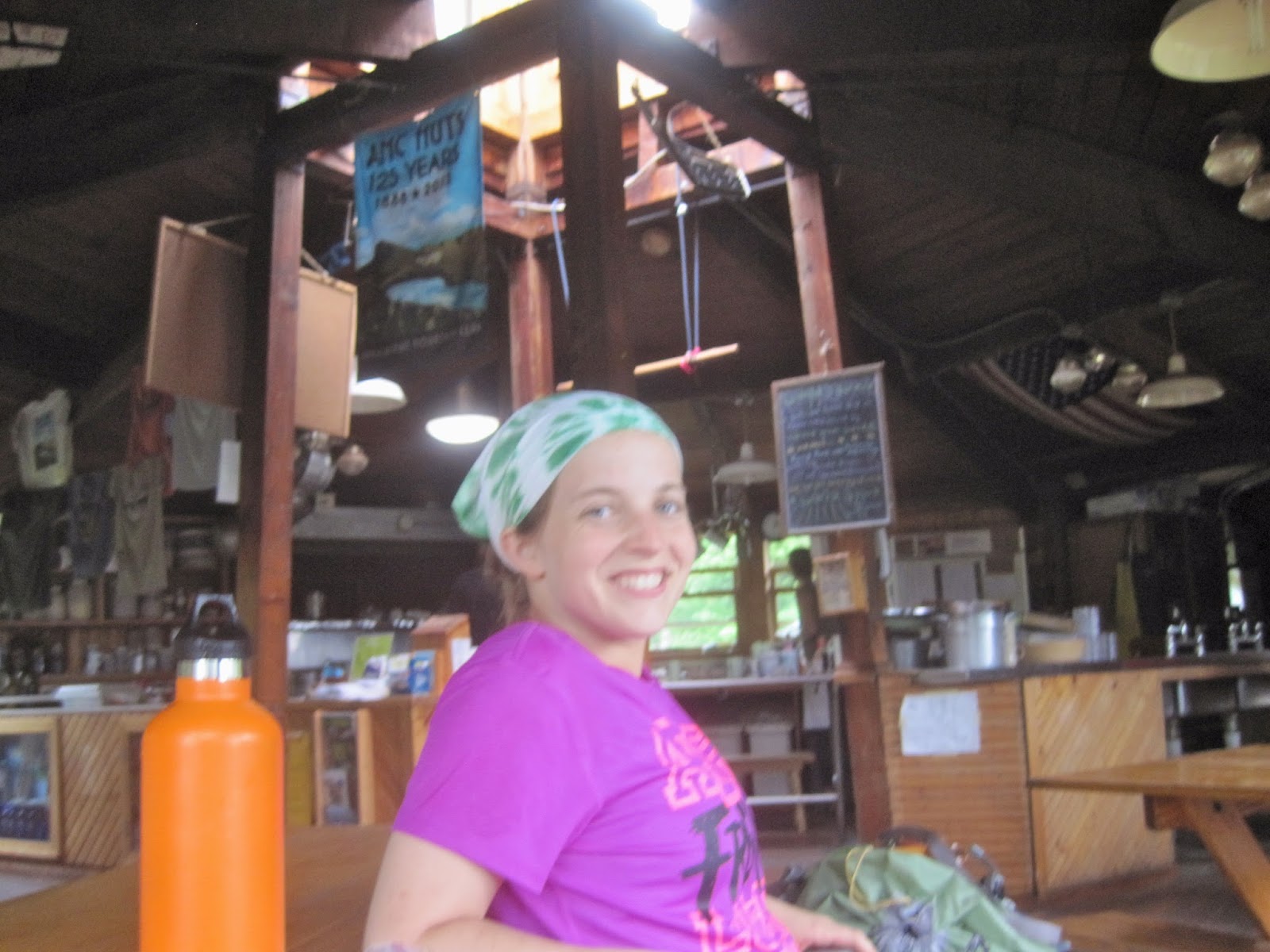
 Ready for our feast

Galehead is a special hut, not only because it is the most remote hut, but because when it was renovated in 2000, it was specifically built to withstand hurricane-force winds.  That was put to the test just a few years ago, when a record-breaking storm ripped through the Whites, with winds recorded at 125mph.  The forests surrounding it were flattened, but Galehead stood strong.  Needless to say, we thought it was a great place to spend the night.  In the summer, each hut is staffed by 5 college-aged "croo" members who run the place and take care of guests.  They serve a full dinner and breakfast and provide bunk rooms and eco-friendly bathrooms for overnight hikers.  Our "croo" at Galehead was actually not the normal staff, but an "All-Star Croo" made up of former hutment and women who had returned to take over for the weekend so that the actual staff could have a weekend off together (usually the staff members are given days off individually in a rotation).  There were married couples who had met and fallen in love working the huts in their college days, some of whom brought along their kids to help.  Needless to say, if I had known about these huts in my college day, I would have been all over it.  What an amazing way to spend the summer.  We feasted on homemade herb bread, pea soup, chicken casserole, salad and blondies for dessert.  Stuffed and warm, we settled into our bunks for a great night's sleep (interrupted only briefly by one of our hut-mates very loud snoring.  I hope you get that checked out, friend).

DAY 3
After being awoken by the Galehead crew's rendition of "You are My Sunshine," being treated to an Olympics-themed skit about proper blanket folding, trash packing and croo tipping, and feasting once again on oatmeal, bacon and pancakes,  we set out from our hut home to conquer South Twin Mountain, our last "big climb" of this piece of trail.  It was one mile of constant near-vertical climb, but once again, the Whites did not disappoint.  We got to enjoy more great views while staying at a relatively high elevation for a bit along another small ridge. 

   Ridges north of South Twin 

After South Twin and some ridges, we gradually descended to another hut.  Zealand Falls Hut is one of the most popular huts, both because it is relatively easy to get to (since multiple trails of varying lengths and difficulty climb up to it) and because it boasts some pretty spectacular scenery, since it is located right next to the waterfall it is named after.  The weather was calling for rain the next day, and we debated staying or pressing on in order to avoid getting wet in the morning.  But we ultimately settled on staying, since the huts are one of the greatest attractions in the Whites.  Because of the high demand for this hut, Amicus and I actually had to find alternate lodging for the night, though I can't say I was sorry when we finally found a place to settle in.  

 Camp Nano by Zealand Falls (water's edge at right)

 Nano taking a dip (Camp Nano at immediate left just out of frame)

After setting up shop at the falls and braving the icy waters (which are very refreshing after your skin goes a little numb) to rinse off and clean up, we did get to visit the hut for dinner.  We actually witnessed one of the Zealand croo members arriving with one of the famous "pack boards," which are nothing more than wooden beams with canvas and rope, which croo members tie (often 50-120 lbs worth of) supplies to, sherpa style, to carry them to the huts.  

 Waiting for supper at Zealand

Zealand's dinner was Thanksgiving in July, complete with turkey, cranberry sauce, mashed potatoes, peas and (vegan) chocolate cake.  The croo members at this hut were the "actual" crew, i.e. a bunch of earthy college kids, but they were no slouches in the kitchen and it was another great night.  I fell asleep listening to the waterfall just outside my tent.

DAY 4
Because we opted to stay at Zealand even though the forecast called for rain on our last day of this leg of the hike, we skipped breakfast at Zealand and hit the Trail bright and early.
 
 Hooter and Nano saying farewell to Zealand Falls

We only had about 8 miles to go to reach our pick-up spot for the day, and luckily those 8 miles happened to be on what is widely known to be the "easiest stretch of trail in the Whites."  From Zealand Hut to the pick-up, the AT followed an old logging road, which meant it was nearly flat and fairly wide.  Most of it was in the woods, but it occasionally emerged from the trees to give a peek at the awesome world around us.  

 Hiking the Logging Road

We made record time on this section, averaging over 2miles/hr and even having time to stop for some food by a pond at just past the halfway point.  The pond was a little off-trail and the caretaker of the tenting site next to the pond came to check on us after hearing Amicus yell at Hooter and I to follow him down the side trail.  She gave us some intel about the area and the weather (just as it started to sprinkle) and asked us to please not leave any food in "her" pond when we left.  It's nice to know someone is paying attention out here.  We made it to the pickup spot in record time (considering we were still, in fact, hiking the Whites, even if the logging road let us forget that for a bit), and didn't even get rained on until we got in the car.  As Hooter would say, timing is everything.  

The first few days back on the AT after a year were a truly wonderful time, complete with some truly "quintessential" AT and White Mountain experiences.  Stay tuned, more adventures ahead. 
   
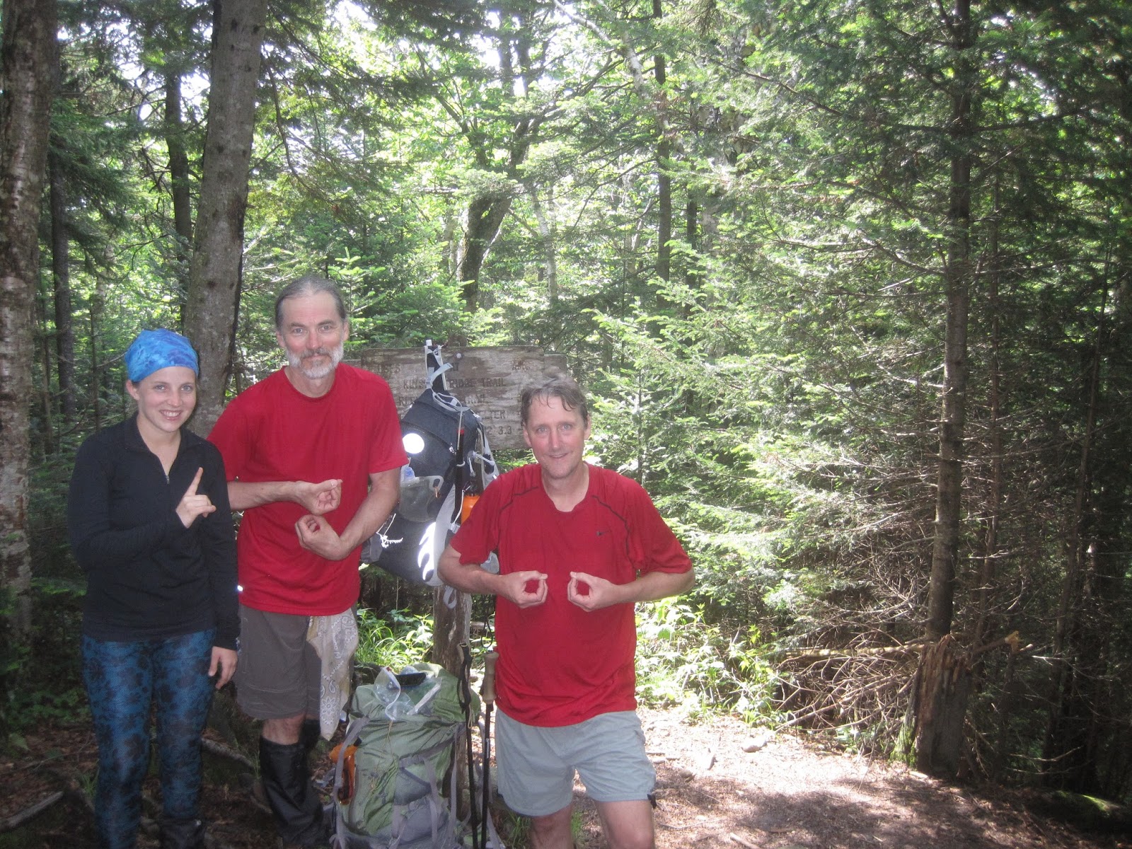
 Team Nano, version 2014

Monday, July 1, 2013

I prefer my AT on the rocks - June 25/26

 1800 Miles Officially Hiked!

The past two days were pretty difficult for Team Nano, but also quite rewarding.  In two days, we hiked a little over 16 miles, which doesn't sound like much, but felt like quite the accomplishment to us.  We worked for every step of this section.  We hit a pretty significant milestone during this outing - we have officially hiked 1,800 miles of Appalachian Trail.  That's a lot of AT under Nano's feet.  On our first day of hiking we went a little over 7 miles.  It was very slow going.  The trail was extremely soggy (standing water along most of it) and we struggled to find any dirt free of rocks and roots to step on.  It's the kind of trail that seems like it's just waiting for you to lose focus and break a hiking pole or an ankle.      You have to watch every single step you take, and plan two steps in advance.  We were going at about 1mph, and we weren't sure how far we would get.  In the middle of the afternoon, we got to a shelter by a river. Since camping is only allowed in the vicinity of shelters in the White Mountains, we had a choice to make.  We could either stay there or hike 4 more miles up and over one of the taller Whites to the next shelter.  The weather forecast was calling for storms, and we thought hiking the wet rocks up a mountain in the rain was probably a bad idea.  So we set up camp by the river and called it an early day.  I think we made the right call, because after a quick dip in the river and starting dinner, the storm found us.  It rained pretty heavily and we were glad to have a good spot to wait it out. 

 Camp Nano by the river in the rain

The next day, the rain had stopped but the fog was thick and the trail was still very wet.  We got a bit of a treat though, because the first mile of hiking followed the river up the steep south side of Kinsman Mountain.  That meant we were hiking next to waterfalls for about an hour. 

 Trail Waterfall

We had about 3 miles to hike to the summit of Kinsman Mountain.  I am starting to discover a pattern that seems to describe 90% of the trails here in the White Mountains - steep rocks.  These trails would be tough even in perfect conditions.  After a heavy rain, when the steep rocks are covered in about a quarter inch of running water, they are even tougher.  Hooter discovered the key to hiking the Whites though - "Stay Focused."  Better advice could not be had. Climbing Kinsman was quite the task.  It was almost as steep as the north side of Moosilake, and just as rocky.  Often, we were crawling on our hands and knees and pulling ourselves up using tree limbs.  We had seen some hikers traveling with dogs along the trail, and all I could think was, if I was struggling up the rocks, how did the pups manage?  Every now and then, the trees would clear and we would get a glimpse of the summit through the fog.    

Our destination

It took up about 3 hours to get to the top of Kinsman.  1mph once again.  I think that's as fast as you are guaranteed to go here in the Whites.  When we reached the summit, it was completely fogged in.  It looked like something out of a horror movie, but getting there meant we had made it up and we thought it was beautiful. 
Foggy Summit of Mt Kinsman

The descent of Kinsman was just as steep and rocky.  It didn't really occur to me while I was hiking (probably because I was so focused on where I was going to put my feet from step to step), but looking back on it now, this kind of trail is legitimately dangerous.  Any pictures I could post would not really do justice to the steepness of the trail.  And with rocks and roots dominating the path, stable places to step are a rarity.  I'm glad that we were careful and took our time.  It's not hard to see how someone could fall and get hurt out here.  Tough going though it was, it was still beautiful.  And very rewarding when you complete it. 
The steep, wet rocks are our favorite...

 Treacherous River Crossing 

There was a very special treat waiting for us with three miles left to go in our hike.  For 125 years, the Appalachian Mountain Club (AMC) has maintained a series of "huts" here in the White Mountains for adventurers to use.  They have evolved over the years from nothing more than walls to the current wilderness palaces they are, complete with bunk houses, bathrooms, a full kitchen and a full time staff that maintains the hut, cooks meals, packs all the supplies up the mountain and offers talks and programs on the local habitats and mountain survivial (what a great summer job that would have been when I was in college).  To top it all off, the huts are largely powered by sustainable energy sources.  Unless you are one of the first two thru-hikers at the hut for the day and can get a work-for-stay deal, there is a (rather substantial by Trail standards) fee to stay at the Huts, but from what I saw they are worth every penny. The hut on our hike today was the Lonesome Lake Hut, one of the newer and more popular huts, since the 3 mile hike to it is relatively forgiving.  It was like Disney World for hikers and we thought we were in heaven.  It had started to rain on our way down Kinsman, so we stopped in to dry off and eat our lunch.  We were so temped to stay (lentil soup, salad, potato rolls, pork chop with homemade applesauce, bow tie pasta, broccoli and homemade dessert were on the menu), but we had to press on. 
 
Lonesome Lake Hut

Lonesome Lake Bunkrooms.  Real Mattresses and all.

Hut Kitchen

It rained for the rest of our hike down Kinsman, but we were in the woods so all we felt was a sprinkle.  As the Hut staff had promised us, the Trail south of the Hut was much more forgiving than the Trail we had put behind us, and we made much better time.  By the time we found Trail Angel at the bottom of the mountain, we were wet as drowned rats and probably just as smelly.  But we were happy to have explored another of the famous Whites.

Team Nano after 2 tough days