Thursday, July 26, 2012

The End of the Line...For Now...

Crossing the state line into New Hampshire
   Today was our last day of hiking for this round of our AT adventure.  We hiked about 8 miles.  We had such luck today, because even though the forecast included a 70% chance of rain and thunderstorms, we only walked in a drizzle for about 20 minutes.  

Last hike on the AT for a while.
    We didn't see many people on the trail today, so it was almost like we had the wilderness to ourselves.  We only stopped once during the entire hike.  At one point, we heard a mooing sound in the distance.  A local had recently told us that this was moose country.  This is also dairy farm country.  I'm choosing to believe what we heard was a moose bidding us farewell.  A little natural Trail Magic.

Non-moose Trail Magic on our last day.  I especially like the hiking boots repurposed as planters. 
   At the very end of our hike today, as part of one of the longest road-walks on the entire AT, we crossed the state line from Vermont into New Hampshire.  I always like ending with some sort of definable milestone.  This trip to the AT is particularly special for me because we took no zero days and it's the first time we've actually made it to our original goal point.  The trail walks right through the middle of Hanover, New Hampshire, home of Dartmouth College.  We said that we would hike to the Dartmouth bookstore.  And that's exactly where we ended up.  I've always said that this experience is not about the destination, but the journey.  I truly believe that, and I am trying to live it.  It's been a year since I was last on the AT, and I have no idea when I'll be able to be on the trail again.  Now, the "real world" is calling me out of the woods.  Once again I find myself saying goodbye to this adventure for awhile, and wondering where it will take me next.  The only thing I know for sure is that this journey is far from over, and the Trail still has much to teach me.  I have been blessed beyond measure with an incredible family and amazing opportunities, both here in the wilderness and beyond.  Happy Trails, friends of Nano.  Until our wanderings bring us together again.
    
An educational ending.
“Though we travel the world over to find the beautiful, we must carry it with us or we find it not.” — Ralph Waldo Emerson

Mileage Update:
Miles Hiked this trip:  196.7
Miles from Springer Mountain:  1,737.3
Miles from Katahdin:  441.1

Wednesday, July 25, 2012

Views of Vermont

Trail Family at 1700 miles.
    We're getting close to the end of this part of our AT journey.  Today we hiked about 15 miles.  It was one of the only days of hiking we've had during this round that contained consistently good views. It was a beautiful day, and since it's the end of July, we even got to enjoy some organic trail treats, since the blackberries are just starting to ripen here in Vermont.

Foraging for blackberries.
    We hiked up lots of small hills today, and through lots of open fields, which is a departure from the "green tunnel"of Vermont forest we've been in for the past couple of weeks.  It was so nice to have such nice views all day.

Vermont Fields. 
     We had to walk on the road through town for the last bit of our hike today.  It's always interesting to see what kind of accommodations - if any - the trail towns make for hikers.  Some towns really go all out to make hikers feel at home.  I love seeing the little bits of trail magic the towns have to offer.

Hiker friendly!

Tuesday, July 24, 2012

Stormy Nights on the AT


Stormy skies on the AT.
   Last night, we did our final overnight on the Trail for this trip on the AT.  We hiked a little over 26 miles in the course of 2 days.  26 miles that ended up being very tough miles.  There were lots of short but steep climbs and descents.  

A bit of high-tech AT mountaineering. 
    The terrain was demanding, but the weather also factored in to our hike this time.  Just as we were looking for a good spot to camp for the night, it started to thunder.  As soon as we got the tent set up and had a bite to eat, the rain rolled in.  It rained for most of the night.  Heavily.  Not just rained, stormed.  At one point, Amicus and I counted 4 seconds between the lighting and accompanying thunder.  Luckily, we had gotten camp set up before the storm began, and all of our gear held up beautifully, which was wonderful.  We didn't even get anything except the tent wet.  We were well prepared, and it actually ended up being a lot of fun.
  
Traversing the AT fields.
   Today, we got to the rendezvous point in time for a yummy hamburger lunch and a little exploring.  We have an extra treat because Trail Sister is here with us now, to join us while we finish this round of our AT adventure.  Here in Vermont, they are very proud of their cheeses and other dairy products, which all come from the fine Vermont dairy farms. We got to visit one of those dairy farms today, and it was full of knowledgable people and beautiful animals.
 
Making some new friends at the the dairy. 

Sunday, July 22, 2012

Mountains and Shelters

Fireplace in a shelter.
      Today we walked about 11 miles, 5 of them uphill and 6 of them downhill.  It was yet another beautiful day, and we passed lots of other hikers on the trail.  We spent the first 5 miles climbing a mountain, only to discover that the AT didn't go to the actual summit and there was no nice view to enjoy at the top.  I prefer my long climbs with a rewarding view at the top.  But it was cool and breezy and sunny and a great day to be in the woods.  We passed a couple of very neat old shelters, one with a fireplace built into it and one with a stone (rather than dirt) floor that must've been built decades ago.  Always something interesting to see on the AT.

View of the Day - interestingly *not* at the top of the mountain. 

Saturday, July 21, 2012

Detours

View of the day
    Today took us about 13 miles further on the Vermont AT.  It was another beautiful day and we climbed a couple of big hills.  We also passed over several streams, and one in particular that was quite large and had people swimming in it and a swinging bridge over it. 

Crossing a river on a swing bridge.

      We made really good time on our hike today, until we got to the last couple of miles.  Then we realized that we had an unexpected surprise to deal with.  About 2 miles of trail in this area was closed in October 2011 due to Hurricane Irene, and it still isn't open yet.  So we had to follow a rather long detour on country roads around the closed trail.  We actually ended up passing Trail Angel on our detour and she followed and walked with us for the last bit of our hike.  Looks like you have to be ready for anything on the AT.  Even dealing with last year's hurricanes!

AT Hurricane Detour

Friday, July 20, 2012

A Good Day for Pictures

Lake with a view.
   Today we hiked about 9 miles in the most perfect of Vermont weather.  I don't have any riveting stories to tell today.  It was a beautiful, relaxing day on the AT with Amicus.  We saw a few people on the trail today and passed a very nice campsite that even had a permanent caretaker living there (his campsite was complete with a gas grill...how he got that 2 miles into the woods, I'll never know).  We finished the days hike at a decent hour and I got to have steak for dinner.  Rather than make up more stories, I'll show you some pictures of the treasures we found on the trail today.
 
World's tiniest frog

Cairn Garden...or eerie sacred hiker burial ground. 

Cliffhugger.  Best view of the day!  

Thursday, July 19, 2012

Rocky Peaks and Piney Forests

Vermont sky and mountains before our hike for the day. 
    Today we hiked a little over 12 more miles of the AT here in Vermont.  We took our time this morning and enjoyed a really wonderful homemade breakfast (I am a huge fan of this sharp cheddar cheese Vermont is famous for) before setting out.  The day couldn't have been more perfect.  It was much cooler today than it has been, with barely a cloud in the sky and a nice breeze.  The hiking was relatively gentle, through thick pine forests.  I've been happy to see the pine forests here.  So many of the east coast pine forests have been destroyed by foreign beetles.  There is evidence of such destruction here.  But there is also evidence of hearty new growth, which makes me happy.  There were lots of pretty streams and bridges and boardwalks on the hike today as well.

AT waterfall and bridge.  
    Even though most of the hike was in the pines, we had a couple of opportunities for great views.  For one of them, we climbed up a sheer, rocky mountainside to get to the summit, but when we turned around to look behind us, we got a real treat.  One of the best views of this section of AT.  Followed up by some delicious ribs for dinner at a local restaurant.  Another great AT day.

Amazing view from a rocky VT summit.

Wednesday, July 18, 2012

Hitting the Slopes

At the top of the mountain. 
    Today we only hiked a short distance - a little over 5 miles - since we had to relocate our "base camp" further north after our big 40 mile push.  Our hike may have been short, but it was very interesting.  It was cloudy and cool with a nice breeze.  On the way up the mountain, about a mile from the top, we stopped on a rock for a water break only to discover 4 snakes who had claimed the rock before us.  First come, first serve I say.  So we moved on.  When we got to the top of the mountain, we spent some time exploring the summit, since the mountain doubles as a ski slope in the wintertime.

Wish we'd taken the chair lift up!
    There were chair lifts and signs all over the summit, labeling the various ski trails.  It's fun to think that during the winter, people can actually snow ski down little bits of the AT.  The view at the top was wonderful.  Apparently there used to be a fire tower at the summit, from which you could see 5 states on a clear day, but the fire tower was taken down this year because it was no longer safe.  We finished our hiking for the day in plenty of time to relocate with Trail Angel to a beautiful Vermont B&B (although "base camp" location for the past week has been wonderful too - the innkeepers were so very nice, and it turned out that their son in law is a doctor at my medical school, and had actually lectured to my class this year...What a wonderful, small world!)  We got to enjoy a relaxing afternoon and a delicious dinner, which I was so glad for after a few days of camping.  I was especially glad to be inside for the night, since being outside for two nights in a row left me covered in mosquito bites.  I think I'll be refilling my big spray soon.

View of the VT hills from the top of the "slopes."

Tuesday, July 17, 2012

More Milestones and Nights in the Woods

Officially past the 1600 mile mark!
    Over the past three days, we've hiked about 40 miles and spent two nights camping.  On Sunday, we celebrated passing the 1600 mile mark.  I'm still blown away when I think about the mileage.  Even though we haven't done it all at once, it makes me smile to see those numbers tick by.  I still have trouble believing we've actually hiked this far.  It's something truly special.  On our first day out, we hiked a little over 14 miles.  It started raining in the late afternoon, and we walked in the drizzle for a couple of hours.  The rain wasn't too heavy, and it cooled things off and filled up the very dry streams, so I was glad to have it.  We camped in the vicinity of a shelter.  A very nice shelter with an expansive view of the mountains.  I was glad that we had taken our sturdier tent and some hot food.  I fell asleep listening to the sound of the rain on the roof of the tent.
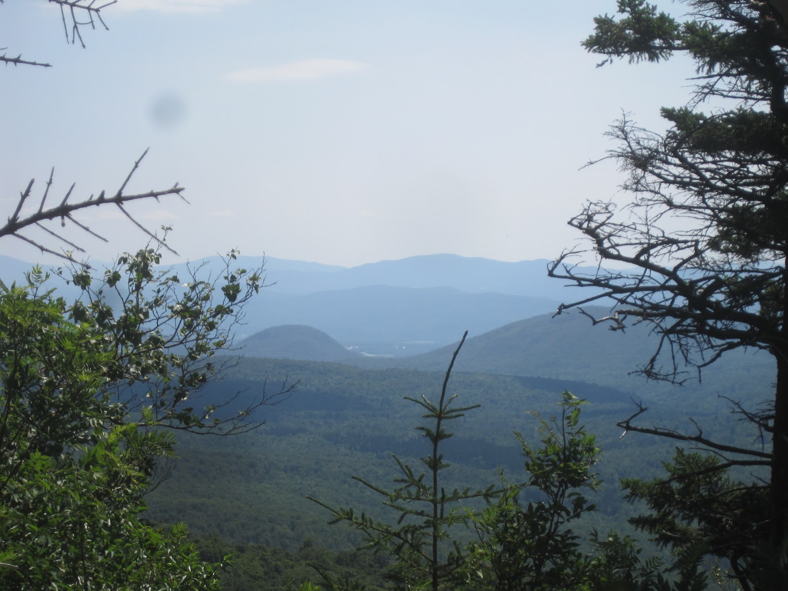
        The next day was quite an accomplishment for us.  We hiked a little over 17 miles.  In the world of Nano and Amicus, that's covering a lot of ground.  We climbed Southern Vermont's highest peak and even ventured up into the abandoned fire tower at the summit (one of two fire towers we climbed over this stretch).

Fire Tower view.
    We also passed a very large lake, which I was tempted to take a swim in, but didn't, since we needed to press on.  While filling up our water bottles, a young man who we'd seen on the trail a couple of times over the past day caught up to us, and while small-talking about the difficulty of summiting the mountain behind us, extolled the virtues of "retroblazing" (otherwise known as taking the old/non-official trail *around* the mountain instead of *over* it) and "iron blazing" (walking along railroad tracks).  I learned some new vocabulary, but I remain true to my AT-purist views.  I am bound and determined to pass every single official white blaze between Georgia and Maine.
  
Break by the Lake
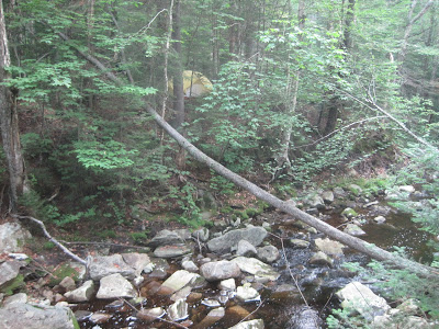
    After 17+ miles of hiking, I was very ready to be finished for the day.  We found a great campsite by a river and had Ramen Noodles on a rock in the middle of the water.  This river was the first river I've seen on the whole AT which didn't look right.  It was an odd yellowish brown color.  We didn't drink from it, but it made an excellent backdrop to our camp.

Camp Nano, deluxe version.
   On our third day of this push, we hiked over 8 miles.  Amazingly, we did it in about 4.5 hours.  Amicus said that I was so motivated to get to the rendezvous point that I went into my special, extra-fast "we're almost to the truck" hiking mode.  One special moment of the morning - we saw a bear!  After we'd been hiking for about a mile, we saw it on the right side of the trail.  It was a very small black bear, and it ran away as fast as it could.  But it was a very special sight.  We made good time and got to the rendezvous point in time for a big, tasty burger lunch and a little exploring around the beautiful small towns in the area.  We even got to feed some gigantic trout and pick up some local organic goodies at a farmer's market for dinner.  Hiking 40 miles over three days is not easy for Nano, but it was so much fun to spend a longer stretch of time in the woods and experience more of what the Vermont AT has to offer.

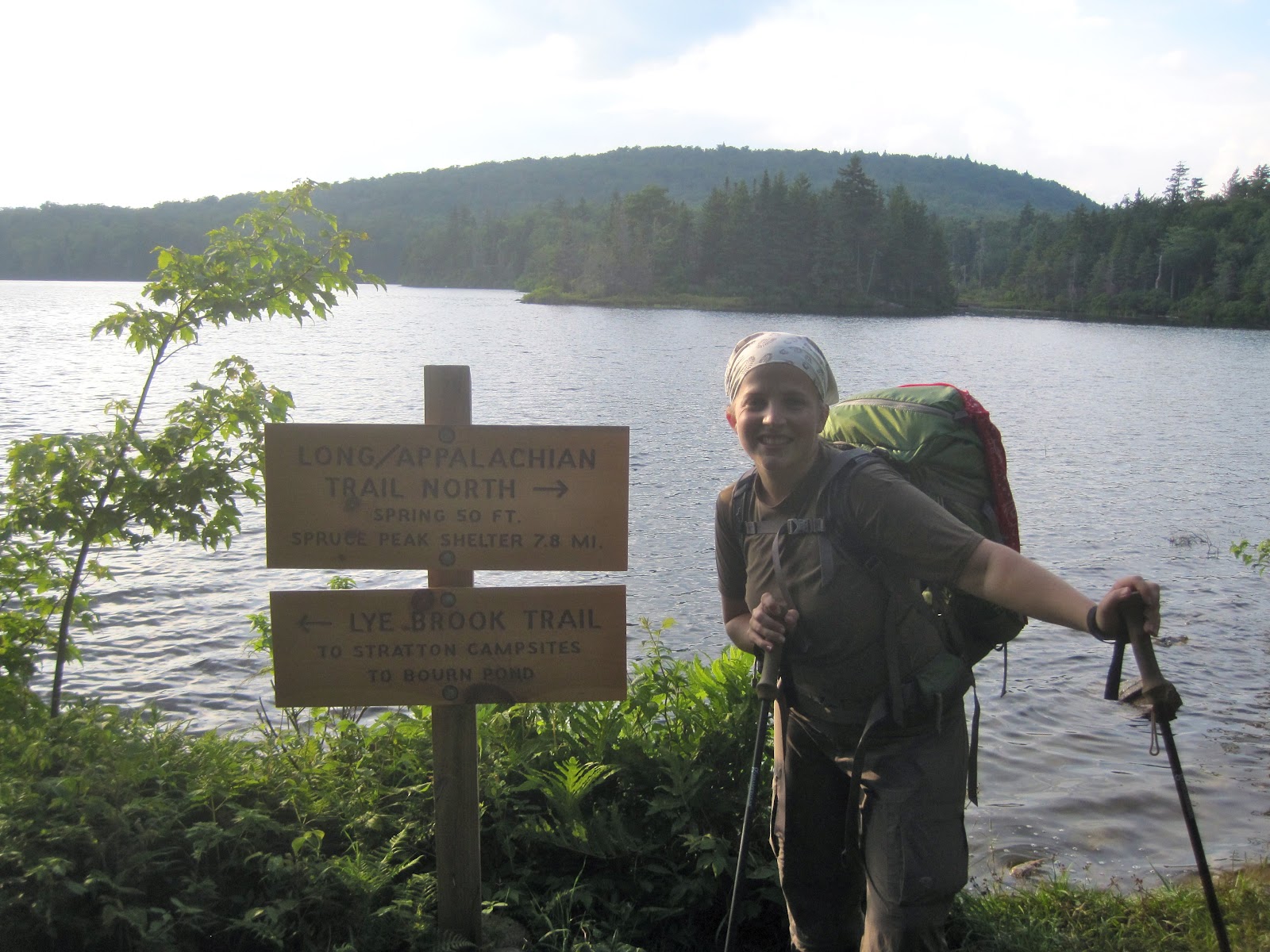
A very happy Nano rendezvousing with her Trail Angel after 40 miles.  

Saturday, July 14, 2012

Welcome to Vermont!

Entering Vermont!
    Over the past two days, we hiked about 19 miles and hit a couple of big milestones.  First of all, we completed another "statesworth" of hiking, crossing over from Massachusetts into Vermont.  That means that we have thus far hiked all of the AT in 11 states, with only 3 more (Vermont, New Hampshire and Maine) left to complete.  That feels pretty excellent.  Also, we broke out the big packs and did our first overnight on the trail for this jaunt on the AT.  We hiked a little over 14 miles on the first day, and about 4 the second.  

Hiking past a giant beaver dam.  We were actually hiking about a foot *below* the water level.  Those beavers are clever engineers! 
    We had more great weather for our overnight trek, though it was quite a bit hotter than it has been.  The creeks and streams are very, very low, if existent at all, due to the prolong dry spell the entire eastern half of the US seems to be experiencing right now, so we made sure to carry extra water.  The place we ended up making camp for the night was actually just uphill from a nice stream and we had our dinner by the water.
Riverside Dining.
    We made our camp for the night in the general vicinity of a shelter, though we didn't stay in the shelter itself.  I believe that except for the shelters in the Great Smoky Mountains National Park over Memorial Day, it was the most crowded shelter we've ever seen.  I'm still surprised by how many Northbound thru hikers are already up here in Vermont.  I commend them on their fleetness of foot.  In talking to them, they seem to average about 25 miles a day.  I pulled off 14 and some change, and I was beat and ready for camp.

Camp Nano
   Overnight, things cooled off pretty drastically, and I was glad I had my sleeping bag, which I had considered leaving behind in favor of a lighter, sheet-like "sleeping sack."  After some surprisingly good sleep (all sleep must seem good after you walk 14 miles), we woke up early and made it to our rendezvous point in time to meet Trail Angel for a delicious late breakfast of omelets at a local restaurant.  We were also able to clean up, do some exploring and enjoy both an AT documentary that was playing in a nearby town (complete with an appearance from one of the filmmakers) and a concert by an alternative loop-pedal musician.  Camping and culture - the AT has it all.

"The Green Tunnel" - pretty representative of the hiking we've been doing recently. 

Thursday, July 12, 2012

Down the Mountain

Good Morning from Mount Greylock.

      Today, after another pretty short hike, we made it down the North side of Mount Greylock.  Amicus and Trail Angel got some amazing pictures of sunrise from the summit, and we had homemade blueberry muffins at the lodge for breakfast.  I can't even begin to say how lucky we've been with the weather so far.  Today was yet another perfect hiking day thought it was a little warmer than it has been.

Leaving the summit. 
   
   The hiking was mostly downhill in the woods with a few vistas along the way.  It was a pretty steep descent with much of the trail covered in roots and rocks, so I was glad that it was dry.  We met a few people on the trail, most of whom seemed to be going up rather than down.  When we got to the base of the mountain we did a short road walk to meet up with Trail Angel.  Today, we spent the afternoon moving our "base camp" a little further north in preparation for next week's stretch of hiking.  We had lunch and dinner at really great local dives, which is one of our favorite parts of the "Trail Experience." I'm happy to have conquered both sides of Massachusetts's highest peak, and it looks like there's going to be some serious hiking done over the next few days, so stay tuned!

Enjoying a view on the descent of Greylock.

Wednesday, July 11, 2012

On Top of Mount Greylock

 View of the top of Mount Greylock...from halfway up Mount Greylock.

   Today was another short day of hiking, with a little over 7 miles under our feet.  The highlight (and really the only goal of the day) was climbing Mount Greylock, the highest peak in Massachusetts.  It stands about 3,400 feet tall and has a war memorial at the top.  We planned to give ourselves lots of time to make it up this peak, since it's been awhile since the only mountains I've conquered lately are mountains of medical memorization.  To my pleasant surprise, we made much better time than I anticipated, taking a few breaks on the way up but not suffering too much.  It was another gorgeous day out, so I could hardly complain.  We were in the woods until we reached the summit, which greeted us with some wonderful views. 

View of the top of Mount Greylock...from the top of Mount Greylock.  In front of the War Memorial.  89 steps to the top with 360 views out of narrow windows.    
 
View from the summit...complete with hang-glider about to launch.  He actually never did launch.  Apparently the winds weren't right.  But his hang-gliding companion managed to launch before this gentleman suited up. 
 
    Since we made fairly good time to the summit, we were able to enjoy our lunch with the views and the breeze.  Trail Angel met us at the top and we had peanut butter and honey sandwiches, courtesy of our good trail friend and master beekeeper Hooter.  Tonight is also pretty special because we are spending the night at the Bascom Lodge on the summit.  It's a recently renovated stone building owned by the state of Massachusetts but privately run.  There was a presentation by some ladies from the local Botanical Society about the various historical gardens in the area, and we had dinner in the lodge's restaurant while we spent some time talking to some locals and fellow travelers.  All in all a successful day at the roof of Massachusetts.
   
Goodnight from Mount Greylock. 

Tuesday, July 10, 2012

Searching for Motivation

Nano and Amicus starting another day on the MA AT.
     Today was a rather short day, hiking wise.  We only hiked about 9 miles, but it was another beautiful day in the Massachusetts forests.  The day was also short on energy for me.  For some reason, I felt like I was dragging all day.  The trail wasn't too difficult today, and it definitely took me longer to hike those 9 miles than it should have.  Maybe there's a disconnect between my mind and my body right now.  My mind says "Hey, let's do this!" and my body says "Wait, I thought we discussed this.  I thought we are all about solitary time in questionably lit and quiet rooms surrounded by medical textbooks now.  Let's not."  I know we'll all get on the same page soon.  I think the first few days of something like this are always the most difficult.  Whatever my muscles might say right now, I'm so glad I'm here.
      We hiked past a very large pond full of lillypads and bullfrogs.  The pond was so calm you could see the reflection of the clouds on the surface.  The bullfrogs were croaking, and it was the middle of the day.  I'd love to hear what that pond sounds like at night.

Bullfrog Pond
  During our hike, we passed two work crews out doing maintenance on the Trail.  I can't even imagine how much work it must take to keep 2,100+ miles (or even 1 mile) of trail maintained so well.  The AT experience surely wouldn't be as wonderful without them.  Towards the end of our hike for the day, we were on the lookout for something called "The Cobbles," which was supposed to have a nice view.  We passed something that we thought was it, but it was so heavily wooded that there wasn't really a view.  We thought it was rather anticlimactic, but hiked on.  We almost missed The Cobbles, because we later realized it was on a bit of a side trail.  I was so glad we took a minute to go off the beaten path, because the view was definitely worth it.
     
MA Valley View
     Since it was a pretty short hiking day, we got done at a decent hour and were able to spend some time thinking about how we're going to approach the next week of hiking, which looks like it might be pretty tough.  We had some delicious tomatoes from home for supper and even got to explore the area a little, which is always fun.

Beautiful old Victorian house in town.  It looks like something from a Zombie movie.  

Monday, July 9, 2012

Treats of all sorts.


Paper Factory in Dalton, MA.  Apparently this is where the paper for US currency is made.
    Today was another beautiful day on the AT.  We hiked about 11 miles today, all of it in the shade of the woods.  It was about 80 degrees again.  Another perfect hiking day.  This day was a great one because it was full of treats.  Before we started our hike, we visited the home of "The Cookie Lady," who lives about 100 yards from the AT.  She and her husband have been serving homemade cookies to weary hikers for 30 years.  Last year, they said they dished out over 1,500 cookies.  They also give out water and provide a yard for camping for those that need it.  Thats some serious Trail Magic right there.

Trail Angel and Nano at the Cookie Lady's house. 
     Over the course of our 11 mile hike, we got to enjoy our first panoramic view of this section.  Since the hiking yesterday (and most of today) was in the thick woods, it was so nice to turn the corner and walk out to open sky.

Enjoying the view.
    We also passed a particularly interesting area that had been completely destroyed by beavers.  All of the trees within about 30 square yards (that we could see) had been completely chewed up and bore the distinctive marks of beaver teeth.  We climbed a couple of small hills and passed through some swampy ground, grabbing lunch on a rock in the middle of the woods.  Part of our hike today passed right through one of the small local towns, and Trail Angel met us and walked with us for a bit.  That was a treat too.  To top it all off, we got to go have some tasty Italian food and see "A Chorus Line" at the local theater.  True trail treats indeed.  

Sea of ferns.