Wednesday, June 30, 2010

Virginia is for Hikers

Choo-Choo! All aboard!

The past 6 days have all been spent out in the wilderness, on the trail. Mamma took a break from being our Trail Angel to go home for a wedding, which left Daddy and I to fend for ourselves for awhile. We hiked almost 80 miles in 6 days, from the edge of North Carolina, across the Virginia border. It was a much different, much harder experience that the shorter overnights we've been doing. First of all, I was carrying several more pounds in my pack than I usually do, and believe me, I noticed the extra weight. Especially climbing the steeper hills. Also, there's something mentally exhausting about knowing that there is no Trail Angel waiting for you in the nice air-conditioned RV at the end of day #3. But, it was lots of fun regardless, and there were lots of exciting things to see. For starters, we accomplished two big milestones: reaching the 400 mile mark on the second day, and the TN/VA border on the sixth day.

400 Miles!

VA State Line! Don't laugh at my spandex. It was day 6 and it was the only piece of clean clothing I had left...

That means that we've hiked through 3 states (GA, NC and TN) and have 10 more to go. I didn't differentiate between NC and TN previously, because the trail doesn't differentiate either, since it literally follows the state line and it's impossible to know whether you're in NC or TN at any given time. VA is the state with the most miles of trail in it, so we'll be here for a while. From what I've seen so far, though, it's going to be great. The first three days of hiking were mostly through really dense, very green forest. The great thing was, although there were very few panoramic mountaintop views, there were lots of beautiful mountain streams and waterfalls.

Snacktime by a small waterfall on Day #1. 10 minutes after that apple was eaten, I was standing under that waterfall. It was amazing.

We camped by one of these small streams the first night, but the most amazing sight of this entire section was at the end of Day #2, when we got to Laurel Fork Falls. I think this is another proper moment to let the pictures do the talking.

Laurel Fork Falls

Crossing the Falls

Camp Nano at the Falls

Trail Leaving the Falls

This was, without a doubt, the best overnight yet, and it's the only place on the trail thus far that I absolutely plan on coming back to one day, if only for a weekend. I got to swim, wash some clothes, and fall asleep to the sound of rushing water. It couldn't have been more perfect, and it's probably not hard to imagine why we didn't leave that spot until 10am the next morning. Day #3 was also filled with beautiful bodies of water, namely Watauga Lake.

Shook Branch Beach at Watauga Lake.

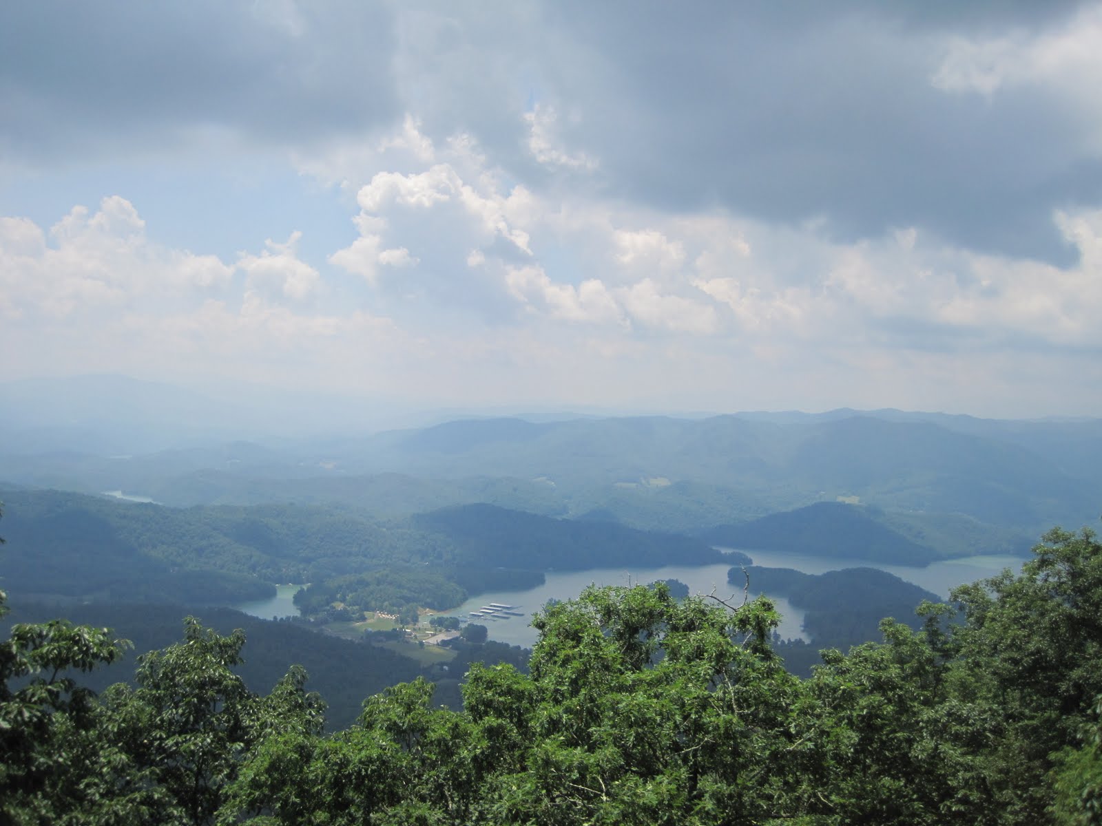
Watauga Lake, Bird's Eye View.

The lake is one of the cleanest in the world, and very popular with the locals. It's big enough to get boats on easily, and people were enjoying their afternoon, skiing, fishing and swimming. It reminded me a lot of KY Lake, and made me more than a little homesick. It was nice to be near familiar surroundings, though. We camped right by the Watauga Dam, and had yet another spectacular campsite, complete with swimming hole.

Watauga Dam, an earthen dam, land side.

Watauga Dam, lake side.

Dinner at Camp Nano, after a swim in Lake Watauga.

Sunset at Lake Watauga.

Not bad for three days in the wilderness, even though it was incredibly hot and humid and I probably lost about 10 pounds in sweat alone. The swimming holes at the end of the day made it all worth it. The next three days didn't involve any swimming holes, but they did involve some easier hiking through some beautiful forest, so we made good time. We met one of the few hikers we saw on this section, "Floater," who had had his food bag broken into by a bear the night before. He was camped just half a mile from us, so we silently thanked the Lord it wasn't our food bag, and gave Floater some of our extra to tide him over. I hope you made it to a grocery, Floater. Happy trails.

Floater and his toothpaste, with one giant bear-tooth puncture in it.

It rained at the very end of day #4, but it didn't start until 30 seconds after we got the tent up to camp for the night. Thank goodness. It was a very close call, but we stayed dry and the rain helped to cool things down quite a bit, which was wonderful. Day #5, like Day #4, was a 16+ mile day. Those long days really wear me out, but there was still plenty to see. One of the most interesting things we saw that day was a handicap-accessible portion of the AT, right next to a highway, complete with a gentle slope and a nice view at the top.

For Handi-capable AT hikers of all sorts.

Short, stubby me struggling to hop the fence at the top of the hill.

Day #6 left us with about 6.5 miles to go to the end of our long hike, and we made it to the trail town of Damascus, VA in time for cheeseburgers and root beer floats for lunch.

Welcome to Damascus!

I hiked that last 6.5 miles in about 2.5 hours. I've never been so motivated to get to the bottom of a hill in my life. Damascus is a great little town, full of southern hospitality and AT love. It was also wonderful to be reunited with the Trail Angel Mamma and have a real shower. Now I only have to do that little 80 mile adventure about 25 more times and I'll make it to Maine...

If that's not the quote of the day, I don't know what is...

Memorable Quotes:

"Me and You is friends.
You cry, I cry.
You smile, I smile.
You hurt, I hurt.
You jump off a bridge,
I gonna miss you."
- Sign at Damascus diner

"Uncle Nick Grindstaff. He lived alone, suffered alone, and died alone." - on a tombstone on the AT. Kinda morbid, no?

"I'd rather be fat than dead." -Me, talking about food, as usual.

Mileage Update:

Miles from Springer: 464
Miles from Katahdin: 1750


Wednesday, June 23, 2010

A Most Interesting and Beautiful Day

One of the overlooks at the end of the hike.

We hiked about 14 miles today, in a little over 8 hours. I have to say, today was the most stunning day of hiking I've had thus far. The terrain was very, very different 80% of the hike was on exposed balds and mountaintops, which is a big change from the heavy forests we've been walking through. We started out with a short climb up some flat, grassy, small balds. We had a great view of Roan Mountain behind us, and some very unusual, but equally beautiful sights ahead.

Top of Jane's Bald, with Roan Mountain in the background.

Goat Family.

That's right - there was a goat pen at the top of one of the first small balds we climbed. It's part of a volunteer environmental research effort to investigate how to best protect the grassy bald ecosystem, which is in danger of being destroyed by invasive plants. The goats love to graze on these invasive plants, so incorporating goat herds into the landscape could preserve its natural beauty. The goat family is tended to all summer by a professional goat herd, weekend volunteers and two Great Pyrenees Mountain Dogs. The babies you see in the picture were, literally, born yesterday. Amazing.

After hiking down the first few small balds, through some forest, and across an old horse path used by Revolutionary War soldiers (so many interesting things learned today...), we reached our big climbs of the day - Little Hump Mountain and Hump Mountain. They were exposed balds too, but larger and steeper than the ones we climbed earlier in the day. Words do not do justice to the beauty of this section of the trail, so I will take this opportunity to let the pictures speak for themselves.

Bottom of Little Hump.

Climb up Little Hump.

Top of Little Hump.

Climb up Hump Mountain.

Lunch break on top of Hump Mountain.

Completely breathtaking. The good thing about hiking all day long on exposed balds is that the views are incredible and you get to enjoy a nice breeze. The bad thing, especially on a day when there's an ozone warning out, is that the sun is very intense. It was pretty hot all day long, and I now have one of the world's greatest farmer's tans, with the added bonus of stripes across my hands from the wrist straps on my hiking poles. I would've put on sunscreen, if I hadn't been distracted by all of the nice views, including a sight I saw right after lunch, which no one would believe unless there was photographic evidence. So, I present...

Wait...is that?...

...oh my gosh, it is...

...a herd of cattle laying in the trail. There were regular cows and longhorns, and there were just hanging out on the AT, standing around chewing their cuds. I was flabbergasted, and honestly a little scared to walk so close to them at first, but they must be used to hikers, because the whole herd completely ignored us. I figured out later that a lot of the land in this area is actually privately owned and often used for farming and livestock, but the farmers allowed the park systems to put the trail through their land. It's probably a pretty good deal, since the park service will then take care of a lot of the upkeep on the property. After getting over my shock at walking through a herd of grazing cattle on the top of a mountain in the middle of nowhere, the rest of the hike was 5 miles downhill, and back into the woods. 14 miles is a long way to go in a day, so I was pretty beat by the end of it. Nothing some good food and some ice cream didn't fix, though. It might be a few days before I post again, since we have a few overnights ahead of us. But if it's half as beautiful as the hiking today, it will be a pleasure.

AT advertising.

Tuesday, June 22, 2010

Cloudland

Roan High Knob Shelter, the highest shelter on the AT. It used to be where the fire warden of Roan Mountain lived until the 1940s.

Today was only a 5 mile hike, but it took us almost 5 hours, which should tell you something about the terrain. The hike was up Roan Mountain, one of the tallest peaks in the southern Appalachians, and it included a 2,000+ foot climb over about 3 miles. Trust me, that's a lot of hill to walk up. We passed a couple groups of hikers going the other way (they looked like middle to high school aged kids from a summer camp, all with matching packs) who seemed surprised that we were hiking up Roan Mountain instead of down it. No pain, no gain, though. It was much cooler today, which made things more bearable. And the views at the top were absolutely worth the effort.

Roan Mountain summit.

Very cool interesting fact - the summit of Roan Mountain used to be the sight of the luxury resort "The Cloudland Hotel" back in the 1800s. People would flock to the mountaintop by railroad and horse and buggy for the pleasant atmosphere and to escape hay fever. The hotel had carpet, huge fireplaces, copper bathtubs, three meals a day, bowling, croquet and a wrap-around porch, all for $2 per day. Now that's a deal. If it still existed, it would be the best AT shelter in existence. Unfortunately, it was torn down to make room for forestry, and now all that's left is the ruins of the hotel's foundation.

Sign with pictures of the Cloudland Hotel in its glory days.

All that remains of the Cloudland. We got done relatively early today, so we took Mamma and Trail Sister up to the top of the mountain (you can drive up it too) to see the ruins.

It was nice to have a shorter day, even if it was very strenuous hiking. We all drove up to the top of the mountain together and walked around for a bit. There are rhododendron gardens at the summit, full of rare Catabwa Rhododendron, which have a much later blooming season and a much brighter color than other rhododendrons. They only bloom for 4 days, and we were here just in time to see the end of the bloom. What luck.
The Dowdy girls in front of a famous Catabwa Rhododendron.

Quote of the Day: "Hey, this is going to sound really strange, but...you wouldn't happen to have a can opener, would you?" - Random Hiker Dad at the shelter. He and his dad and his son (3 generations...cool) were out hiking with 100+ pounds of gear for 2 days, and apparently had canned food. And nothing to open it with. We found them later after we got to the RV and gave them one.

Monday, June 21, 2010

International Hike Naked Day

ln(AT)

Today was about a 9.5 mile hike that we finished in just over 5 hours. The guidebooks have this section rated as "moderate" but that is all lies. There were plenty of steep climbs to tackle today, and it definitely got my blood pumping. I can't decide what's worse: a very, very steep climb that only lasts for a few tenths of a mile, or a tortuously gradual climb that seems to tease you with it's "gentle incline" and goes on for miles. I hiked both today, and both were equally painful. There were some beautiful things to see, as always though, and it was another beautiful day to be out.

Snacktime.

Peek-A-Boo!

Top of the big climb of the day.

Did I get your attention with the title of this post? Thought so. I wasn't just teasing, either. Today is, indeed, International Hike Naked Day, during which outdoor enthusiasts and those who have no problem with public nudity are supposed to gallivant about the wilderness in nothing but their birthday suits. I wish I had some hilarious pictures and stories, but alas, I neither participated in IHND nor encountered anyone who was. Maybe it's a bigger deal up North?

Sunset in the mountains.


Sunday, June 20, 2010

Happy Father's Day!

Me and my Daddy.

This Father's Day was a glorious, beautiful Sunday for a hike, even though it was a bit hotter than it has been. We went about 12 miles in just under 7 hours, which was really an accomplishment, considering the terrain included two 1,000+ foot climbs and descents. The first point of interest was a place called, literally, "Beauty Spot." And for a good reason. The panoramic views spoke for themselves. Apparently there's an annual strawberry festival at this location too, which sounds like a lot of fun. Unfortunately, it was not being held today.

Beauty Spot.

The second big climb, considerably harder than the climb up Beauty Spot, was up Unaka Mountain...

Unaka Mountain in the background, as seen from Beauty Spot.

...and even though the climb was tough, it was worth it when we got to the top, because there was a very special, very surprising treat waiting for us - a whole mountaintop of live pine forest! After hiking through miles and miles of blighted, dead pines, I was so happy to see what seemed like a healthy and thriving, if recovering, grove of pine trees. It looked like this forest had regrown since the attack of the parasitic pine bugs, and was doing well.

Beautiful pine forest.

The rest of the hike was downhill and relatively uneventful. We saw another family of wild turkeys, but nothing else (if anyone has ever seen a turkey fly, it's one of the most bizarre sights nature has to offer. Those things just weren't meant for the air...), not even any other hikers.

I love my Daddy every single day, but as a final note, since it is Father's Day, I would like to wish all the Daddies, Grand-Daddies and Father-Figures out there a blessed day, but most especially mine, who is the finest man I know. I love you Daddy, and I'm glad we are on this grand adventure together.

Daddy and his girls out for Father's Day dinner.

Quote of the Day: "This is my child. She went to college. Twice. Now she's unemployed." -Daddy, in reference to me.

Mileage Update:

Miles from Springer: 360
Miles from Katahdin: 1,818

PS - I'm realizing, after almost 6 weeks out here, that my readers my be starting to find my ramblings about my daily walks uninteresting. While the sights and sounds of the trail are still totally fascinating to this easily entertained nerd, I may not be writing about what you really want to hear. So here's my proposition. If you'd like to ask me any questions, or know anything specific, leave me a comment here on the blog, or email me. I promise I will respond to all inquiries in subsequent posts.

Saturday, June 19, 2010

Rivers and Streams

All aboard the AT train!

I am very happy to report that my hiatus from hiking to take care of my health and my future medical education is over. We left the big city after my MCAT on Thursday morning, which I am very glad to have behind me. I also officially submitted my initial application to medical school this week, so I suppose this means it's real now. Luckily, there's a bit of a waiting period to get through before I have to start filling out secondary applications, so I can focus on my adventure for a few weeks. Over the past two days, we've hiked about 21 miles, 12 on Friday and 9 today. The 12 miles on Friday was some of the easiest terrain I've seen so far, and we hiked the whole 12 in less than 6 hours, which is quite an accomplishment for these little short legs. Today was more difficult, with some steep climbs and rocky sections. The weather has been absolutely gorgeous. To add to the visual delights, most of this section of the trail seemed to involve hiking along streams and rivers. Not only is it a gorgeous sight to walk along a bubbly mountain stream, but the water cools off the air around it, making the whole experience more pleasant in this June heat.

Mountain Stream and footbridge.

Nolichucky River, bird's eye view.

Nolichucky River, up close and personal.

Overall, great days to be out on the trail. Friday was another day that we hiked the entire day without seeing anyone else. Creepy but a pretty awesome, powerful feeling as well. Saturday, we got a late start because we stopped to join the citizens of this tiny TN town as they lined the interstate to honor the first of their own, a 24 year old young man, to be killed in the war in the Middle East. There were cars and people lining the roads for miles, most of them bearing American flags, and the funeral procession was dozens of vehicles long. This show of support for a fallen soldier was an incredibly moving sight. Prayers to the family of this young man, who gave his life for his country. Thank you for your service and your sacrifice.

We finished our hiking goal today in time to have a delicious meal at the Hawg-n-Dawg (yes, they sell BBQ and hot dogs...I actually had the BBQ hot dog, which was amazing) and catch "The A-Team" at the local theater. Can't ask for a much better day than that.

Tower of peanut butter and ice cream. Best end to a day of hiking ever.